Réserver une Démo

Ce webinaire est terminé, l’enregistrement sera affiché sous peu.

Aperçu

Comment pouvez-vous utiliser des outils de modélisation à la fine pointe de la technologie pour concevoir et documenter vos géodatabases?
Comment lier et retracer les géodatabases existantes avec d’autres parties de votre modèle d’entreprise?
Ce webinaire répond à ces questions importantes et démontre la conception d’une géobase de données Arcgis dans Enterprise Architect.

Ben Constable, analyste principal chez Sparx Systems, répond à ces questions importantes et vous montre comment:

INSCRIVEZ-VOUS AUJOURD’HUI!

Ne manquez pas cette occasion d’en savoir plus sur Enterprise Architect

Session 1

Melbourne Sun 16 February 08:00 am
New York Sat 15 February 16:00 pm
Los Angeles Sat 15 February 13:00 pm
London Sat 15 February 21:00 pm
Auckland Sun 16 February 10:00 am

Session 2

Présentateurs

Ben ConstableSparx Systems

Explorez les ressources du webinaire

Exemple modèle: bpmn-webinar-cephas-example-model.eap Liens de Téléchargement
XML workspace document Générate: house-meter-geodatabase.xml Liens de Téléchargement
ArcGIS modèle queries : arcgis-model-custom-queries.xml Liens de Téléchargement

Questions et Réponses

Général

Enterprise Architect 11 was used during the demonstration. Nearly all of the demonstrated functionality, however, is available in the latest release of Enterprise Architect 10 (Build 1010). For this webinar topic, the only notable differences between versions 10 and 11 are the availability of enhanced report templates in Enterprise Architect 11 and the expanded ArcGIS context menu available when you select a Workspace package in the Project Browser.

A public beta release of Enterprise Architect 11 is already available. See the beta release web page for details. The date of the Général availability (GA) release has not been provided at this stage.

Oui. Enterprise Architect supports import of Visio models. There is an additional script that you need to run after importing your model, which ensures that the ArcGIS UML profile is compatible with Enterprise Architect. For complete instructions, see our web page on importing ArcGIS Visio models.

The Building class was left as an unstereotyped abstract class. The House class, however, was stereotyped as Point, because we wanted a simple example that included a Feature Class. So for the purpose of the example, it suited us to treat houses as nothing more than a dot on a map.

Not that we are aware of. However we would welcome any inputs from users who have done this. Please get in touch with us via [email protected] or submit an article on our community site: http://community.sparxsystems.com

Oui. We've made the queries available for download from this page.

Here's an explanation of the queries and how to use them:

  • Find Related Classes. Lists every RelationshipClass connector for the class that you name in the search field, along with the related Class and the origin and destination cardinality.
  • Find Relationship Classes — Go to Connector. Lists all relationship classes in the model. Double-click a result to jump to the connector properties.
  • Find Relationship Classes — Go to Origin Class. Lists all relationship classes in the model. Double-click a result to jump to the origin class properties. Right-click to find the origin class in the Project Browser or diagrams.
  • Find Domain References. Lists all element fields for which the type matches the Domain name that you specify in the search term.

To use these custom queries, first import them into Enterprise Architect from the XML file:

  1. Save the XML file somewhere.
  2. Open any Enterprise Architect model.
  3. Invoke Enterprise Architect's model search tool via the main menu: Edit > Find In Project.
  4. Click the Builder button to show the toolbar icons. The icon with the 'down arrow' is the icon for importing searches.
  5. Click the import search icon.
  6. Choose the file that you saved in step 1.

Now you can run the queries from any Enterprise Architect model. For example, to Find Domain References:

  1. Open your model in Enterprise Architect and invoke the model search tool via the main menu: Edit > Find In Project.
  2. In the Search field, type the name of the Domain element to which you want to find references.
  3. In the Search drop-down list, choose Find Domain References.
  4. Click Run.

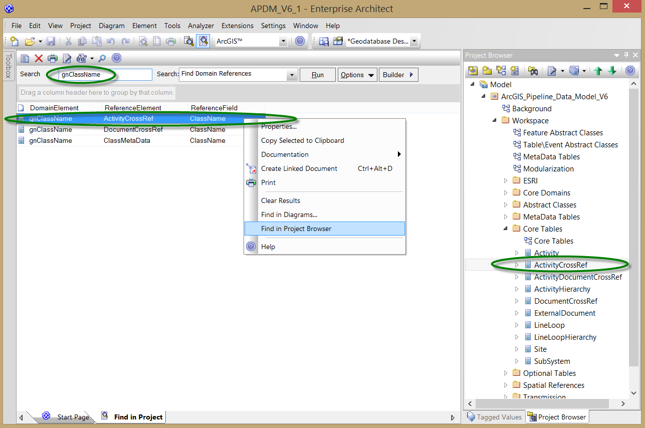
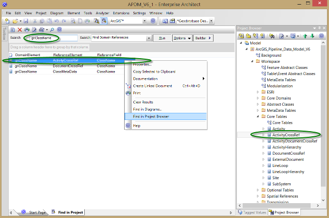
The list of results has three columns:

  1. DomainElement: The name of the Domain element, which will always match your search term.
  2. ReferenceElement: The name of the element — a Feature Class or Table — that refers to your DomainElement.
  3. ReferenceField: The name of the field within the referring element.

As shown, you can right-click any of the results to navigate to the referring element in diagrams or the Project Browser, or view its properties. You can also drag and drop any of the search results from the list onto an open diagram to add the referring element to that diagram.

Find Domain References

Custom queries allow you to search for ArcGIS-specific model information.

Oui. The main template and its sub-templates (Template Fragments) are included in the example model that you can download from this page. Please note that these are prototype templates for use with Enterprise Architect version 11. We are developing more complete data dictionary templates for ArcGIS, which will be available in a future release of Enterprise Architect. If needed, you can create similar templates for earlier versions, using Enterprise Architect's template editor.

Support de la Fonctionnalité ArcGIS

Our support for modeling ArcGIS geodatabases was first tested with ArcGIS 10.0. Earlier versions of ArcGIS that support the XML Workspace import and export capability may also be compatible with Enterprise Architect.

Professional edition, or above. See our web page that compares Enterprise Architect editions.

No. As mentioned above, the latest release of Enterprise Architect 10 (Build 1010) is sufficient. Some relevant enhancements will be included, however, in the Enterprise Architect 11 release.

Enterprise Architect supports topology, geometric networks and various other spatial types supported by ArcGIS. For more information and an example, search the Enterprise Architect User Guide for: topology.

The features that we support for Geometric Network are similar to what earlier CASE tools supported:
  • Create geometric networks
  • Define which Feature Classes are involved in the geometric network.
  • Create connectivity rules among the Feature Classes in the geometric network.

No. Currently users cannot set a Weight on each Feature Class.

We plan to support Annotations and Dimensions in future. We have noted this request for Parcel Fabric.

Enterprise Architect supports the Geographic, Projected and Vertical Coordinate Systems used by ArcGIS.

Oui. Enterprise Architect supports definition of Relationship Rules, Connectivity Rules and Topology Rules.

Deltas de Modèle et de Schéma

Enterprise Architect supports model differencing, so you can compare a current Workspace model to an earlier snapshot and a list of differences is displayed. You can see added or changed items such as Classes, Attributes (fields) and Tagged Values. For more information, see the Enterprise Architect User Guide topic on Model Baselines.

We do not, however, currently provide a facility to automatically write these changes out to an existing geodatabase. We hope to release that capability in future.

As mentioned above, this will be available with a future release.

Modèle APDM

The draft Modèle APDM we showed was provided courtesy of Pete Veenstra, on behalf of APDM. Earlier versions of this model are available in Visio format only. APDM 6 will be the first release of the modularized model, in Enterprise Architect.
The ArcGIS Pipeline Data Model (APDM) has not yet been released in Enterprise Architect format. It should become available later this year on the APDM website: www.apdm.net

Support des Bases de Données spatiales, autres qu’ArcGIS

Currently there is no specific support in Enterprise Architect for other types of spatial databases. We have noted numerous requests for PostGIS and the spatial types of other relational databases.
ArcGIS is currently the only GIS-specific platform that we support; however Enterprise Architect is used in numerous other contexts for spatial information modeling. As one example, Enterprise Architect provides a profile for the Geography Markup Language (GML), which is used in projects to define interoperable spatial data exchange formats.
Basic support for spatial data types was added for relational databases with Enterprise Architect 11, including for SQL server. Notice the geometry and geography entries in the type drop-down list for columns in a SQL Server table.
Enterprise Architect does not automatically establish such a link for you, at this stage.
Partagez cette page Partagez par email Partagez sur LinkedIn Partagez sur X Partagez sur facebook